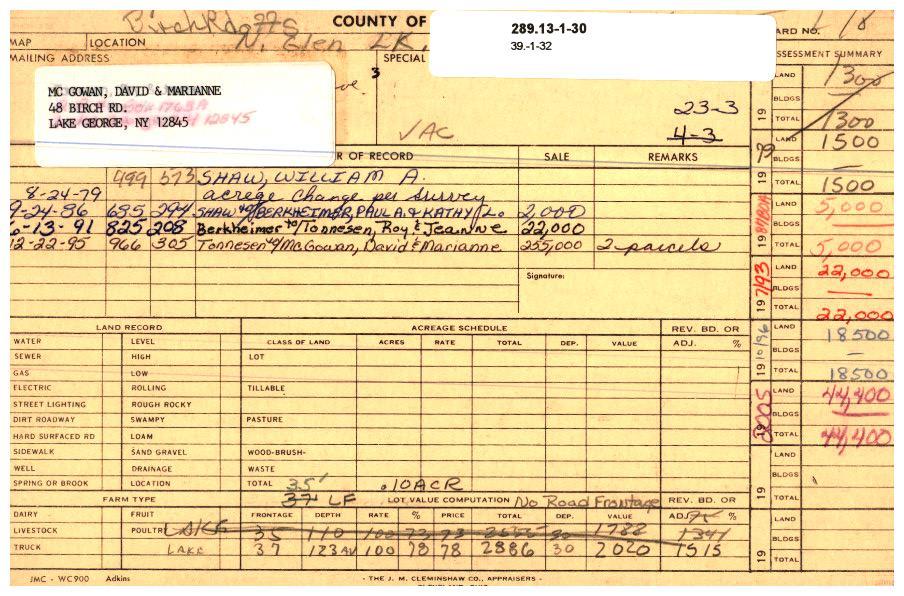
289.13-1-30 * Birch Rd.,off
Please Notice:
- To see the content pertaining to this parcel click the + image to hide click the - image in the main section header you are looking to view.
- When printing, if you click the + (show) or - (hide) you can print only the information you wish to see
- If you would like to Hide / Show all, click the appropriate link below
Hide All | Show All


Parcel Information:
| Parcel | Location | Acres | Property Class | School District | Ward |
| 289.13-1-30 | Birch Rd.,off | 0.1 | 311 - Res vac land | Lake George Csd | Ward 1 |

Owner Information:
| Owner | Owner Address | P.O. Box | Owner Address Line 3 |
| David McGowan | 48 Birch Rd | | Lake George NY 12845 |
| Marianne McGowan | 48 Birch Rd | | Lake George NY 12845 |
| Parcel | Assessed Land Value | Assessed Total Value | Uniform % | Full Market Value |
| 289.13-1-30 | 65,000.00 | 65,000.00 | 90.00% | 72,200.00 |

Images:

Sales Information:

Site Information:
| Site # | Nbhd Code | Sewer | Water | Utilities | Site Desire | Nbhd Type | Nbhd Rating | Road Type | Entry Type | Zoning Code |
| 1 | 123-Glen Lake | Private | Private | Electric | Typical | Suburban | Average | Improved | No entry | WR |

Land Information:
| Site # | Land # | Type | Front | Depth | Acres | Sq Ft |
| 1 | 1 | 10-Waterfront | 37 | 123 | 0 | 0 |

Residential Building Information:

Commercial Building Information:

Improvements Information:

Special District Information:
| Special District | Units | Taxable |
| EM001-Emergency medical | 0 | 65000 |
| FP007-Fire protection | 0 | 65000 |
| GL001-Glen Lake Protect | 1 | 0 |
| LB001-Crandall library dst | 0 | 65000 |

Exemption Information:

Permit Information:
| Permit Number | Permit Date | Permit Use | Cost Estimate |
| 0720-2018 | 11-27-18 | septic alt | 0.00 |
The information in the  RPS database is maintained by the Town of Queensbury Assessors Office
 2025 Assessment Values: